
14th Street, East River Bikeway and Esplanade
2023.029.0977

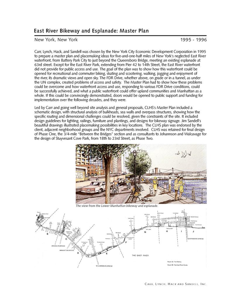
Carr, Lynch, Hack, and Sandell was chosen by the New York City Economic Development Corporation in 1995 to prepare a master plan and placemaking ideas for five-and-one-half miles of New York’s neglected East River waterfront, from Battery Park City to just beyond the Queensboro Bridge, meeting an existing esplanade at 63rd street. Except for the East River Park, extending from Pier 42 to 14th Street, the East River waterfront did not provide for public access and use. The goal of the plan was to show how this waterfront could be opened for recreational and commuter biking, skating and scootering, walking, jogging and enjoyment of the river, its dramatic views and open sky. The FDR Drive, whether above, on grade or in a tunnel, as under the UN complex, created problems of access and safety. The Master Plan had to show how these problems could be overcome and how waterfront access and use, responding to various FDR Drive conditions, could be successfully achieved, and what a public waterfront could offer upland communities and Manhattan as a whole. If this could be convincingly demonstrated, doors would be opened to public support and funding for implementation over the following decades, and they were.
“Led by Carr and going well beyond site analysis and general proposals, CLHS’s Master Plan included a schematic design, with structural analysis of bulkheads, sea walls and overpass structures, showing how the specific routing and dimensional challenges could be resolved, given the constraints of the site. It included design guidelines for lighting, railings, furniture and plantings, and designs for bikeway signage. Jim Sandell’s beautiful drawings illustrated placemaking possibilities in key locations. The CLHS plan was endorsed by the client, adjacent neighborhood groups and the NYC departments involved. CLHS was retained for final design of Phase One, the 3/4-mile ‘Between the Bridges’ section and as consultants to Johannson and Walcavage for the design of Stuyvesant Cove Park, from 18th to 23rd Street, as Phase Two.”
Phase I Implementation: “The CLS design for the Phase I, "Between the Bridges" segment, starting at the Fulton Fish Market and extending 3/4 of a mile to Pier 35, demonstrates the recreational potential of the East River and set a standard for the bikeway paving and marking, esplanade paving and furniture, river edge railing, lighting, and signage. Here, the FDR drive is overhead, making access to the river's edge easier, this first segment was immediately embraced by the lower Manhattan and the lower East Side communities, attracting a continuous stream of daily users.”
Bikeway and Esplanade Today: “Over the 28 years since the Master Plan, various sections were completed as funding became available. The segment shown in the plan below, from 38th to 60th Streets, is now (2023) partially complete. Built high over the river to protect against rising sea level, the 6,000 foot long Greenway platform, in the rendering below, will be extended past the United Nations campus, as in our Master Plan. Where on land, there is a protecting flood wall on the upland side.”
2023.029.0977
2023.029.0978
2023.029.0979

Principal
Project manager; architect