

Hudson River Waterfront Master Plan
Description
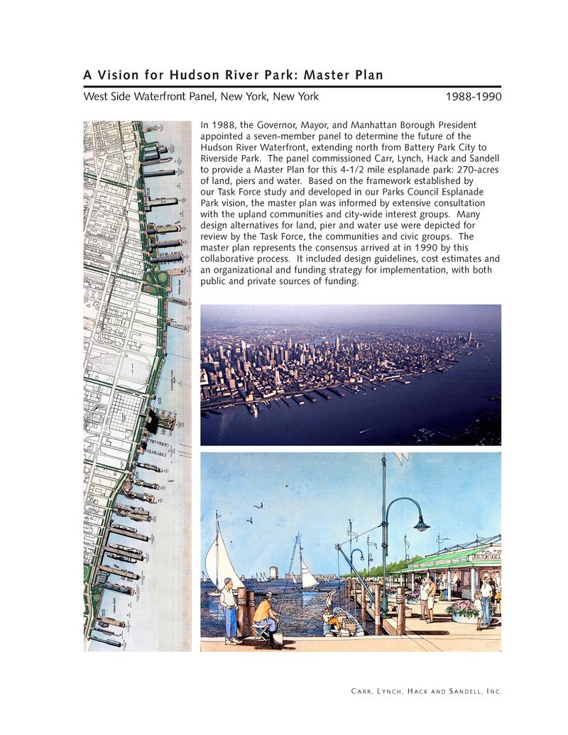
Master Plan: "In 1988, the Governor, Mayor, and Manhattan Borough President appointed a seven-member panel to determine the future of the Hudson River Waterfront, extending north from Battery Park City to Riverside Park. The panel commissioned Carr, Lynch, Hack and Sandell to provide a Master Plan for this 4-1/2 mile esplanade park: 270-acres of land, piers and water. Based on the framework established by our Task Force study and developed in our Parks Council Esplanade Park vision, the master plan was informed by extensive consultation with the upland communities and city-wide interest groups. Many design alternatives for land, pier and water use were depicted for review by the Task Force, the communities and civic groups. The master plan represents the consensus arrived at in 1990 by this collaborative process. It included design guidelines, cost estimates and an organizational and funding strategy for implementation, with both public and private sources of funding."
Design Framework: “The design framework of Hudson River Park, includes the bikeway, the esplanade, linear green spaces unique to each neighborhood and the 28 piers, most to be rehabilitated with new recreational uses. Distinctive entrance plazas should welcome park visitors at the ends of the major cross-town streets. The bikeway had to have a consistent design, but green spaces, the esplanade, the piers all could vary depending on waterfront configuration and upland neighborhoods.”
Development Options: “As the planning and urban design consultant to the West Side Waterfront Panel, Carr, Lynch, Hack and Sandell investigated development options along the Waterfront. In the Chelsea area, one proposal envisioned adapting and extending a series of non-viable cargo piers and reusing them for a mixture of housing and office space. This development would generate revenue for the park. We proposed a small boat basin adjacent to the piers which would accommodate private boats and dinner cruiseboat operations. Between the boat basin and Gansevoort Peninsula, we proposed two new islands to replace the remnants of former piers providing access to floating restaurants and other waterborne uses. Existing structures of historical and/or architectural significance were to be preserved and a large active-use park was shown on the site of the former Sanitation Department operations. Both of these ideas have been realized in Hudson River Park as "Little Island" and the Gansevoort Park.”
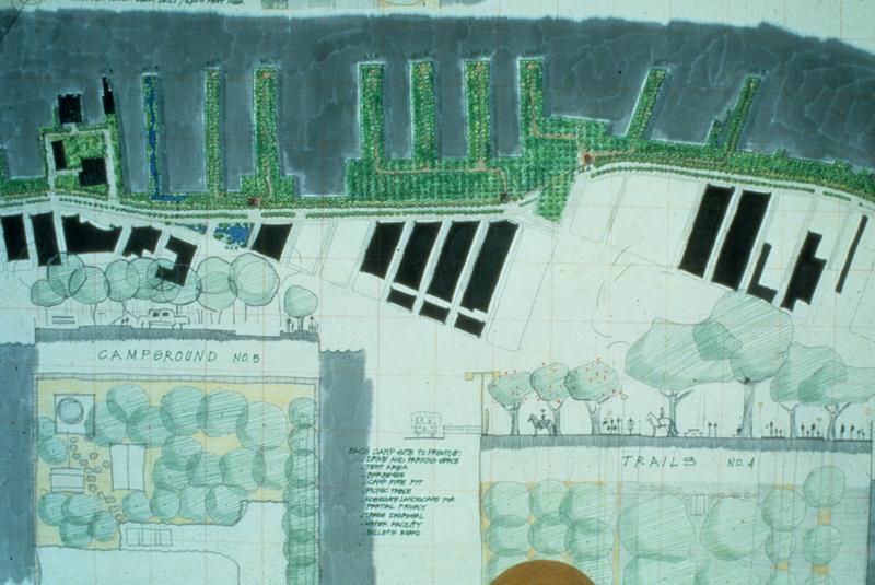
Re-Use Options: “Working with the Westside Waterfront Panel, upland communities and civic groups, Carr, Lynch, Hack and Sandell produced a wide range of urban design options for the re-use of pier and water areas along the Hudson River waterfront. Each stretch of waterfront demanded a different approach based on the existing pier configuration and on community input. The range of program elements for the Chelsea waterfront and piers included passive and active green space, excursion boat facilities, water taxi docks, tugboat tie-ups, cafes, public restrooms, floating restaurants and swimming pools, indoor and outdoor sports facilities of various kinds, centers for river ecology, green markets and other commercial uses.”
Additional Resources:
- Filings by Chelsea Piers LP (https://www.secinfo.com/$/SEC/Filings.asp?CIK=929702)
- Later work by Quinnell Rothschind & Partners (https://www.qrpartners.com/project/hudson-river-park/)
- Later work by M. Tobin (https://mtobinco.com/chelsea.html)
- Later work by Michael Sorkin Studio (http://www.sorkinstudio.com/westside-waterfront)
- Later work my Matthews Nielsen (https://mnlandscape.com/projects/Pier_55 and https://www.mnlandscape.com/projects/hudson_river_park_pier_25)
Related objects
Hudson River Waterfront design exhibition invitation
2023.029.0593
Hudson River Waterfront design competition entry
2023.029.0594

